


-
-
Home
-
- About Upazilla
- Upazila Parishad
- Administration
- Municipality
-
Government Offices
About Human Resources Development
-
□ Upazila Social Services Office
-
□ Upazila Women Affairs Officer\'s Office
-
□Upazila youth development officer\'s office
-
Cooperative Office
-
Upazila Rural Development Office
-
□ National Women Organization
-
□One House One Farm Project
-
□ Upazila Information Center
-
Small Farmer Development Foundation, Upazila Office
-
Polli Darido Bimochon Foundation (Pdbf)
-
□ Upazila Social Services Office
- Other organizations
- e-Services
- Photogallery
-
-
Home
-
-
About Upazilla
Upazilla Introduction
History-Tradition
Geographical and Economic
Public representatives
-
Upazila Parishad
Upzzila Porishod
Chairman office
Upazila Parishad activities information
-
Administration
Upazilla Nirbahi Officer
Office of the UNO
Important information
- Municipality
-
Government Offices
Land affairs
Agriculture and food related
About Human Resources Development
- □ Upazila Social Services Office
- □ Upazila Women Affairs Officer\'s Office
- □Upazila youth development officer\'s office
- Cooperative Office
- Upazila Rural Development Office
- □ National Women Organization
- □One House One Farm Project
- □ Upazila Information Center
- Small Farmer Development Foundation, Upazila Office
- Polli Darido Bimochon Foundation (Pdbf)
Education related
Engineering and communication
Other offices
-
Other organizations
Educational Institution
Private companies
Religious Institution
Projects
-
e-Services
National e-service
Mobile App
Union Information and Services Center
-
Photogallery
Photo Gallery
Video Gallery
Bheramara at a glance
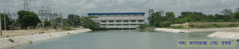
Bheramara Upazila is located 23 km Northwest of Kushtia district headquarters. The total area of the upazila is 153.62 sq km. The Upazila is surrounded by Padma River to the North-West, Mirpur to the East and South, Daulatpur upazila to the West and Kushtia Sadar upazila to the East. It was established as a police station in the British period. Afterwards on 6 January 1982, it was promoted as an upazila. This upazila consists of 1 municipality and 6 unions namely: Bahadurpur, Mokarimpur, Bahirchar, Chandgram, Dharampur and Juniadah. The total number of villages in this upazila is 61 and the number of mouzas is 43. Total population of the upazila is 1,75,480. Among them 90,600 are men and 84,60 are women.
|
Area |
153.72 sq Km |
|
Population |
2,00,084 (According to 2001 Census) |
|
Municipality |
1 |
|
Union |
6 |
|
Number of Village |
81 |
|
Mouzas |
43 |
|
Literacy Rate |
74% |
|
Colleges |
4 |
|
Secondary School |
23 |
|
Alim Madrasa |
1 |
|
Dakhil Madrasa |
3 |
|
Govt. Primary School |
34 |
|
Non-Govt. Primary School |
19 |
|
River |
3 |
|
Pump House |
1 |
|
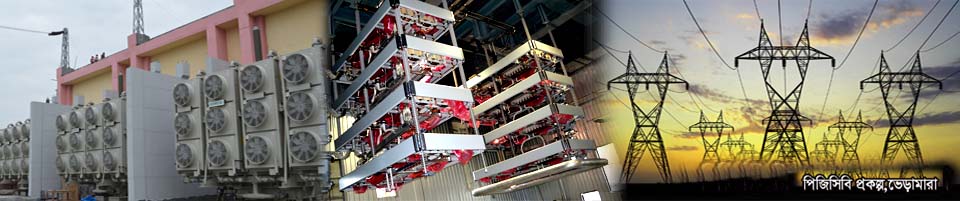
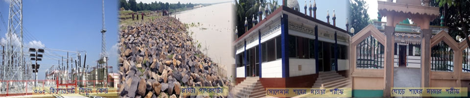
Power House |
2 |
|
Sub- Register Office |
1 |
|
Schedule Office (Tahshil Office) |
7 |
|
Marriage Registration Office |
7 |
|
Police Station |
1 |
|
Police Camp |
3 |
|
Health and Family welfare Centre |
1 |
|
Public Library |
1 |
|
Rest House |
2 |
|
Market |
8 |
|
Club /Organization |
33 |
|
Post Bungalow (Dak Bangla) |
1 |
|
Health Project |
1 |
|
Food Warehouse |
5 |
|
Filling Station |
4 |
|
Saw Mill |
9 |
|
Pulse Mill |
4 |
|
Railway Station |
1 |
|
Tele Phone Exchange |
1 |
|
Tele Gram Office |
1 |
|
Post Office |
8 |
|
Cinema Hall |
3 |
|
Bank |
11 |
|
NGO |
12 |
|
Cultural Organization |
10 |
|
Cooperative Societies |
203 |
|
Shelter Project |
3 |
|
Railroad |
15 |
|
Paved Road |
203 km |
|
Unpaved Road |
126 km |
|
Bridge |
7 |
|
Culvat |
60 |
|
Real Freedom Fighters |
192 |
|
Number of Casualities |
8 |
|
Under Sanitation |
15,344 Family |
|
Arsenic infected Tube wells |
2325 |
|
Arsenic Free Tube wells |
7643 |
|
Number of Adult Allowance |
4583 |
|
Number of Widow Allowance |
1955 |
|
Resettled Families |
369 |
|
Total Land Area |
15,370 Hectares |
|
Arable Land |
11,951 Hectares |
|
Agricultural Land |
10,409 Hectares |
|
Landless Famers |
5050 |
|
Irrigated Land |
600 Hectares |
|
Deep Tube well |
12 |
|
Hand operated Irrigation Machines |
290 |
|
Number of Ponds |
1210 |
|
Govt. Fishery |
1 |


Planning and Implementation: Cabinet Division, A2I, BCC, DoICT and BASIS
Technical Assistance:
![]()
Developed By:
